Quote of the Month:
“Nature gives to every time and season some beauties of its own." - Charles Dickens
“Nature gives to every time and season some beauties of its own." - Charles Dickens
| Distance: | 3.2 miles, RT |
| Difficulty: | 3/5 |
| Rating: | 4/5 |
| Who are allowed: | Dogs are allowed |
| Hiking Time: | 3 hrs |
| Elevation Gain: | 1,350 ft |
| High Point: |
5,685 ft |
| Snow Free: | June - October |
| Trailhead Pass: | Not required |
| Local Maps: | Green Trails No. 301 Randle |
| Contacts: | Gifford Pinchot National Forest Cowlitz Valley Ranger Station 10024 U.S. 12 Randle, WA 98377 Tel: 360-497-1100 |
| GPS Coordinates: | Trailhead: N 46° 39.992', W 121° 53.499' Fire Lookout: N 46° 41.065', W 121° 54.083' |
 High Rock is considered to be one of the most stunning lookouts in Washington. High Rock Lookout trail is perfect for hikers who are looking for a spectacular view of Mount Rainier and the surrounding areas, it’s not long but it is steep.
For most of your way, you’ll be going through mountain hemlock and silver fir and you way will be lined with bear grass. In early summer, hikers will enjoy the colors of lupine, paintbrush and other blossoms. There are not so many view opportunities during the hike, but when you come closer to the end everything opens perfectly up.
When you start hiking, the trail is easy to deal with, but the further you go the steeper it becomes. The elevation at the top of the trail is 5,685 feet. But still you may see lots of children and elderly people hiking here.
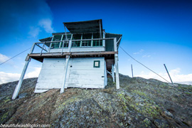
 At the end of the hike you will see not only the most picturesque vies, but also you will see an old fire lookout tower built in 1929, it needs some restoration, but it is also open for the visitors. Years ago people had to hike over 10 miles to get to this fire lookout.
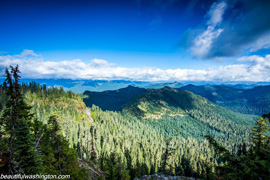
The panorama at the top is great, Mount Rainier with its glaciers fascinates you mostly, but here you will admire the views of the Tatoosh Range, Mount Wow and the Glacier View Wilderness peaks.
At the end of this trail look straight down, about 1,500 feet, for a picturesque view of Cora Lake. If you look south and east you will be amazed by the beauty of Mount Adams and Mount St. Helens.
 There is no need to be in a hurry, enjoy this beauty, especially in the evening when the sunset gets closer.
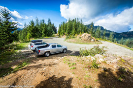
Getting to High Rock Trail: From Ashford, follow Highway 706 2.3 miles, turn right on Kernihan Road for 1.3 miles. Follow this road as it turns to the left onto Skate Creek Road (FSR 52) and follow for 4.7 miles. Turn right onto graveled FR 84 and follow for 6.8 miles bearing right onto FR 8440. Continue 2.7 miles to trailhead at Towhead Gap.
 High Rock lookout trail 01
High Rock lookout trail 01
High Rock lookout trail 01
 High Rock lookout trail 02
High Rock lookout trail 02
High Rock lookout trail 02
 High Rock lookout trail 03
High Rock lookout trail 03
High Rock lookout trail 03
 High Rock lookout trail 04
High Rock lookout trail 04
High Rock lookout trail 04
 High Rock lookout trail 05
High Rock lookout trail 05
High Rock lookout trail 05
 High Rock lookout trail 06
High Rock lookout trail 06
High Rock lookout trail 06
 High Rock lookout trail 07
High Rock lookout trail 07
High Rock lookout trail 07
 High Rock lookout trail 08
High Rock lookout trail 08
High Rock lookout trail 08
 High Rock lookout trail 09
High Rock lookout trail 09
High Rock lookout trail 09
 High Rock lookout trail 10
High Rock lookout trail 10
High Rock lookout trail 10
 High Rock lookout trail 11
High Rock lookout trail 11
High Rock lookout trail 11
 High Rock lookout trail 12
High Rock lookout trail 12
High Rock lookout trail 12
 High Rock lookout trail 13
High Rock lookout trail 13
High Rock lookout trail 13
 High Rock lookout trail 14
High Rock lookout trail 14
High Rock lookout trail 14
 High Rock lookout trail 15
High Rock lookout trail 15
High Rock lookout trail 15
 High Rock lookout trail 16
High Rock lookout trail 16
High Rock lookout trail 16
 High Rock lookout trail 17
High Rock lookout trail 17
High Rock lookout trail 17
 High Rock lookout trail 18
High Rock lookout trail 18
High Rock lookout trail 18
 High Rock lookout trail 19
High Rock lookout trail 19
High Rock lookout trail 19
Leave your comment