Quote of the Month:
“Nature gives to every time and season some beauties of its own." - Charles Dickens
“Nature gives to every time and season some beauties of its own." - Charles Dickens
| Distance: | 4 miles, RT |
| Hiking Time: | 2 hrs |
| Elevation Gain: | 600 ft |
| High Point: | 7,006 ft |
| Best time to visit: | Middle of July till September |
| Trailhead Pass: | National Park Pass Required |
| GPS Coordinates: | Trailhead: N 46° 54' 57.00", W 121° 38' 37.50" Dege Peak: N 46° 55' 6.72", W 121° 36' 38.70" |
 Description
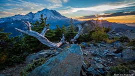
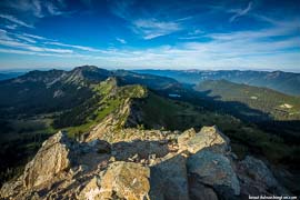
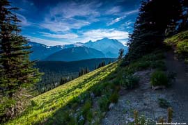
Sourdough Ridge Trail is a well-maintained trail along the crest of a 7,000 feet ridge and was named for the sour bread preferred by minors. This trail takes its visitors through beautiful alpine meadows with wildflower displays and offers, probably, the best views of Mount Rainier.
The trail starts at the Sunrise Visitor’s Center that is considered to be the highest point (6400 ft) in this area that is reached by car. This place is great because it offers a great number of trails which take their beginning from the parking lot.
 South Ridge Trail offers a little bit different views of the ridge, because visitors enjoy the other side of the drop off of the ridge.
If you turn right from the trailhead, you will pass and enjoy four small peaks, the last one is called Dege Peak. Here you will find a trail, which is considered to be the easy one, which takes you to the top of Sourdough Ridge.
Here at the elevation of 7,006 feet hikers will enjoy the stunning views of Mount Rainier. Visitors are recommended to turn around and to find the familiar places that are situated at your feet. On a clear day you may also find Mount Adams which is located to the south. From this place it seems that it is a small hill in comparison to Mount Rainier that you face.
 Mount Baker can be also identified from Sourdough Ridge, it is located north of Dege Peak. On the west above the visitor’s center there are the Burroughs Mountains and on the northeast you may see Fremont Lookout and Grand Park.
It should be said that Sourdough Ridge is not as crowded as other nearby trails. On your way the hikers may encounter ground squirrels and high meadows deer. Be sure to watch for mountain goats and black bears that live in the northern basins along Sourdough Ridge.
 Sourdough Ridge trail 27
Sourdough Ridge trail 27
Sourdough Ridge trail 27
 Sourdough Ridge trail 01
Sourdough Ridge trail 01
Sourdough Ridge trail 01
 Sourdough Ridge trail 02
Sourdough Ridge trail 02
Sourdough Ridge trail 02
 Sourdough Ridge trail 03
Sourdough Ridge trail 03
Sourdough Ridge trail 03
 Sourdough Ridge trail 04
Sourdough Ridge trail 04
Sourdough Ridge trail 04
 Sourdough Ridge trail 05
Sourdough Ridge trail 05
Sourdough Ridge trail 05
 Sourdough Ridge trail 06
Sourdough Ridge trail 06
Sourdough Ridge trail 06
 Sourdough Ridge trail 07
Sourdough Ridge trail 07
Sourdough Ridge trail 07
 Sourdough Ridge trail 08
Sourdough Ridge trail 08
Sourdough Ridge trail 08
 Sourdough Ridge trail 09
Sourdough Ridge trail 09
Sourdough Ridge trail 09
 Sourdough Ridge trail 10
Sourdough Ridge trail 10
Sourdough Ridge trail 10
 Sourdough Ridge trail 11
Sourdough Ridge trail 11
Sourdough Ridge trail 11
 Sourdough Ridge trail 12
Sourdough Ridge trail 12
Sourdough Ridge trail 12
 Sourdough Ridge trail 13
Sourdough Ridge trail 13
Sourdough Ridge trail 13
 Sourdough Ridge trail 14
Sourdough Ridge trail 14
Sourdough Ridge trail 14
 Sourdough Ridge trail 15
Sourdough Ridge trail 15
Sourdough Ridge trail 15
 Sourdough Ridge trail 16
Sourdough Ridge trail 16
Sourdough Ridge trail 16
 Sourdough Ridge trail 17
Sourdough Ridge trail 17
Sourdough Ridge trail 17
 Sourdough Ridge trail 18
Sourdough Ridge trail 18
Sourdough Ridge trail 18
 Sourdough Ridge trail 19
Sourdough Ridge trail 19
Sourdough Ridge trail 19
 Sourdough Ridge trail 20
Sourdough Ridge trail 20
Sourdough Ridge trail 20
 Sourdough Ridge trail 21
Sourdough Ridge trail 21
Sourdough Ridge trail 21
 Sourdough Ridge trail 22
Sourdough Ridge trail 22
Sourdough Ridge trail 22
 Sourdough Ridge trail 23
Sourdough Ridge trail 23
Sourdough Ridge trail 23
 Sourdough Ridge trail 24
Sourdough Ridge trail 24
Sourdough Ridge trail 24
 Sourdough Ridge trail 25
Sourdough Ridge trail 25
Sourdough Ridge trail 25
 Sourdough Ridge trail 26
Sourdough Ridge trail 26
Sourdough Ridge trail 26
From Seattle:
Travel I-5 south to SR 18 East to Auburn, take SR 164 to Enumclaw, then continue east on SR 410 for 37.5 miles. Turn right onto the Sunrise Road and continue for 12.7 miles to trailhead at Sunrise Point.
Photo: Roman Khomlyak
Information: Marina Petrova
Leave your comment