Quote of the Month:
“Nature gives to every time and season some beauties of its own." - Charles Dickens
“Nature gives to every time and season some beauties of its own." - Charles Dickens

 Length: 4.6 miles
Location: Issaquah, King County
GPS Coordinates: N 47 31.383 W 122 03.466
Central Peak in Squak Mountain State Park can be achieved through the Bullitt Fireplace Trail and Central Peak Trail. Total length of the trail is 4.6 miles.
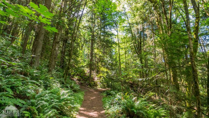
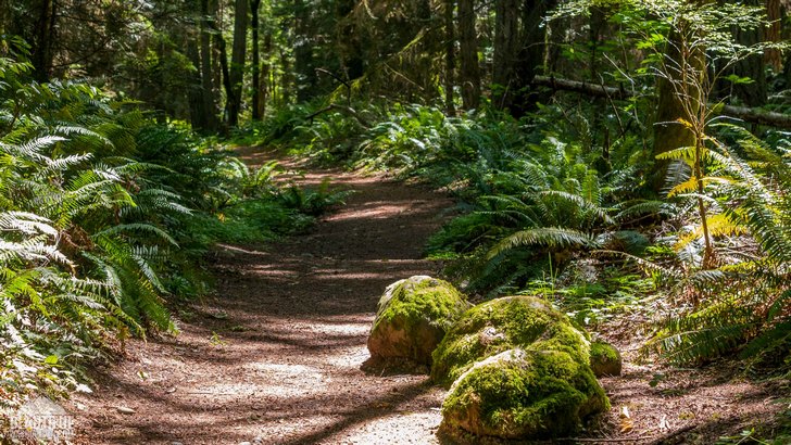
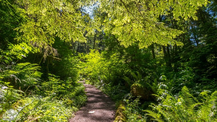
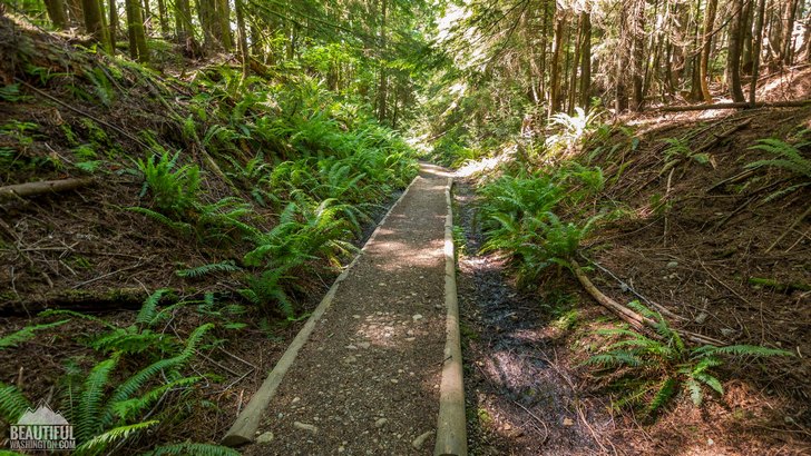
Both of the trails are well-maintained and easy to hike. After the rain they get muddy. From the parking lot the hikers are taken in the forest, most of the hike is under forest canopy, so the views from the open spaces are limited here.
The trail system in the Squak State Park is extensive, but also it is well-marked. It is easy to find your way there.
The biggest part of Squak Mountain was privately owned by Bullitt family. After a short walk from the parking lot hikers will see the Bullitt Fireplace. This is the only thing that has remained from a family vacation home.
After passing the Bullitt Fireplace, the trail intersects with the Central Peak Trail. The trail goes up and becomes steeper. Soon you’ll reach the summit and will enjoy the views of the town of Issaquah and other parts of the area.
Several words should be said about the Squak Mountain itself. This mountain is situated between Cougar Mountain to the west and Tiger Mountain to the east. Squak Mountains consists of three main peaks: the Central Peak with an elevation of 2024 ft, the West Peak with an elevation of 1995 and the Southeast Peak, its elevation is 1673 ft.
Squak Mountain Park was established in 1972. The part of the land was granted to the city by the Bullitt family. Right now the territory of the park is 1,545 acres.
 Central Peak Trail 1
Central Peak Trail 1
Central Peak Trail 1
 Central Peak Trail 2
Central Peak Trail 2
Central Peak Trail 2
 Central Peak Trail 3
Central Peak Trail 3
Central Peak Trail 3
 Central Peak Trail 4
Central Peak Trail 4
Central Peak Trail 4
 Central Peak Trail 5
Central Peak Trail 5
Central Peak Trail 5
 Central Peak Trail 6
Central Peak Trail 6
Central Peak Trail 6
 Central Peak Trail 7
Central Peak Trail 7
Central Peak Trail 7
 Central Peak Trail 8
Central Peak Trail 8
Central Peak Trail 8
 Central Peak Trail 9
Central Peak Trail 9
Central Peak Trail 9
 Central Peak Trail 10
Central Peak Trail 10
Central Peak Trail 10
 Central Peak Trail 11
Central Peak Trail 11
Central Peak Trail 11
 Central Peak Trail 12
Central Peak Trail 12
Central Peak Trail 12
 Central Peak Trail 13
Central Peak Trail 13
Central Peak Trail 13
 Central Peak Trail 14
Central Peak Trail 14
Central Peak Trail 14
 Central Peak Trail 15
Central Peak Trail 15
Central Peak Trail 15
 Central Peak Trail 16
Central Peak Trail 16
Central Peak Trail 16
 Central Peak Trail 17
Central Peak Trail 17
Central Peak Trail 17
 Central Peak Trail 18
Central Peak Trail 18
Central Peak Trail 18
 Central Peak Trail 19
Central Peak Trail 19
Central Peak Trail 19
 Central Peak Trail 20
Central Peak Trail 20
Central Peak Trail 20
 Central Peak Trail 21
Central Peak Trail 21
Central Peak Trail 21
 Central Peak Trail 22
Central Peak Trail 22
Central Peak Trail 22
 Central Peak Trail 23
Central Peak Trail 23
Central Peak Trail 23
 Central Peak Trail 24
Central Peak Trail 24
Central Peak Trail 24
 Central Peak Trail 25
Central Peak Trail 25
Central Peak Trail 25
 Central Peak Trail 26
Central Peak Trail 26
Central Peak Trail 26
 Central Peak Trail 27
Central Peak Trail 27
Central Peak Trail 27
 Central Peak Trail 28
Central Peak Trail 28
Central Peak Trail 28
 Central Peak Trail 29
Central Peak Trail 29
Central Peak Trail 29
 Central Peak Trail 30
Central Peak Trail 30
Central Peak Trail 30
 Central Peak Trail 31
Central Peak Trail 31
Central Peak Trail 31
 Central Peak Trail 32
Central Peak Trail 32
Central Peak Trail 32
 Central Peak Trail 33
Central Peak Trail 33
Central Peak Trail 33
 Central Peak Trail 34
Central Peak Trail 34
Central Peak Trail 34
 Central Peak Trail 35
Central Peak Trail 35
Central Peak Trail 35
 Central Peak Trail 36
Central Peak Trail 36
Central Peak Trail 36
 Central Peak Trail 37
Central Peak Trail 37
Central Peak Trail 37
 Central Peak Trail 38
Central Peak Trail 38
Central Peak Trail 38
 Central Peak Trail 39
Central Peak Trail 39
Central Peak Trail 39
 Central Peak Trail 40
Central Peak Trail 40
Central Peak Trail 40
 Central Peak Trail 41
Central Peak Trail 41
Central Peak Trail 41
 Central Peak Trail 42
Central Peak Trail 42
Central Peak Trail 42
 Central Peak Trail 43
Central Peak Trail 43
Central Peak Trail 43
 Central Peak Trail 44
Central Peak Trail 44
Central Peak Trail 44
 Central Peak Trail 45
Central Peak Trail 45
Central Peak Trail 45
 Central Peak Trail 46
Central Peak Trail 46
Central Peak Trail 46
 Central Peak Trail 47
Central Peak Trail 47
Central Peak Trail 47
 Central Peak Trail 48
Central Peak Trail 48
Central Peak Trail 48
 Central Peak Trail 49
Central Peak Trail 49
Central Peak Trail 49
 Central Peak Trail 50
Central Peak Trail 50
Central Peak Trail 50
 Central Peak Trail 51
Central Peak Trail 51
Central Peak Trail 51
These picture were taken on June 07, 2016
How to get to the park:
Take I-90 and exit 17. Continue right onto Front Street N and follow the road till W Sunset Way. Sunset Way changes into Mountain Park Boulevard. In about 0.9 miles turn left onto Mountainside Drive. Continue going to the parking lot.
In order to get directions click on the link below
Photo: Roman Khomlyak
Photo Editing: Juliana Voitsikhovska
Information: Marina Petrova
Leave your comment